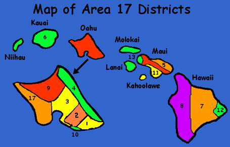
#1—Diamond Head
The Diamond Head district is the area from Makapuu Point along the Ala Wai Canal to McCully Street. The district is bounded by the Koolau Mountains on the North and the Pacific Ocean on the South.
#2—Honolulu
The Honolulu district is the area from Middle Street on the West and McCully Street on the East. The North boundary is the Koolau Mountain range and the South boundary is the Pacific Ocean.
#3—Leeward
The Leeward district is the area from Middle Street on the East and Kunia Road and West Loch of Pearl Harbor on the West. The North boundary is the Koolau Mountain Range and Ka Uka Blvd to include Village Park. Southern boundary is the Pacific Ocean.
#4—Windward
The Windward district is the area from Kahuku Point to Makapuu Point, and is bounded by the Koolau Mountains on the East and the Pacific Ocean on the West.
#5—No Ka Oi
The Central Maui district includes Kahului, Puunene, Wailuku, Waihee & Kahaukaloa. Upcountry Maui—Kula, Makawao, Pukalani & Haiku. East Maui—Keaneae, Hana, Kipahulu and Kaupo.
#6—Kauai
The island of Kaua’i.
#7—Hilo-Hamamkua
The Hilo-Hamakua district is the Eastern half of the Big Island South from Honokaa up to but not including Shipman Park.
#8—West Hawaii
The West Hawai’i district is the Western half of the Big Island from Hawi South to Naalehu and East to Honokaa; including Waimea.
#9—Central North Shore
The Central North Shore district is the Area from Kaena Point to Kahuku Point. The district is bounded by the Koolau Mountain range on the East and the Waianae Mountain range on the West. The South boundary is Ka Uka Blvd.
#10—Waikiki
The Waikiki district is the Area inside the Ala Wai Canal including all of Kapiolani Park. From the Ala Wai Canal to the ocean and East to Paki Avenue continuing south to the intersection of Diamond Head and Kalakaua Avenue.
#11—Kihei
The Kihei district is bounded on the North by Maalaea and down through Kihei, Wailea and Makena. Also including the island of Kaho’olawe.
#12— Puna
The Puna district is the Puna area of the Big Island from Shipman Park in Keaau to Volcano to Kalapana.
#13—Tri-Island
The Tri-Island district is bounded on the South by MacGregor Point. Includes Lahaina, Honokawai, Napili up to Kahaukoloa. Also includes the Islands of Moloka’i & Lana’i.
#17—Waianae
The Waianae district is the area from Kunia and West Loch of Pearl Harbor on the East and Kaena Point on the West. The North boundary is the Waianae Mountain Range and the South boundary is the Pacific Ocean.
